Geography meets Infographic: The True Size of Africa

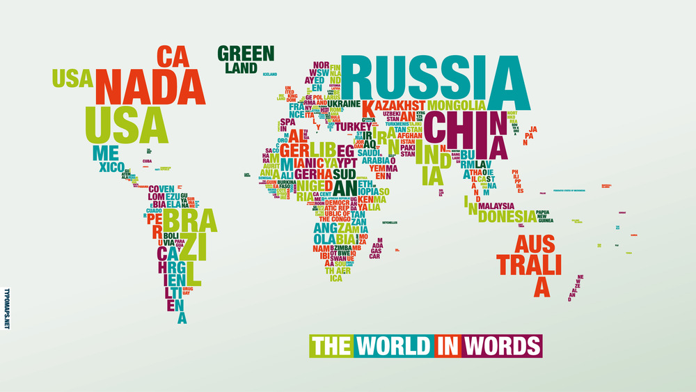
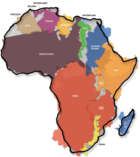
Africa is really big, in fact big enough to fit the United States, China, India, Japan, and much of Europe within its borders. This is exactly what the illustrator Kai Krause shows us with his inventive map/infographic “The True Size of Africa”, which he describes as his contribution to “the fight against rampant Immappancy”, meaning insufficient geographical knowledge.


You can download the full size version of the map here. 

Via http://www.informationisbeautiful.net/

Geography meets Stereotypes: The Geography of Prejudice

Mapping Stereotypes: The Geography of Prejudice is a project by London-based graphic designer, illustrator and photographer Yanko Tsvetkov aka AlphaDesigner. As you should be aware of, a “sense of humor is highly recommended”.

Europe_according_to_the_vatica
Europe_according_to_the_usa
Europe_according_to_russia
Europe_according_to_germany
Europe_according_to_france
Europe_according_to_gay_men

In order of appearance:
– Europe According to The Vatican

– Europe According to USA
– Europe According to Russia
– Europe According to Germany
– Europe According to France
– Europe According to Gay Men

Be sure to view more cool stereotypes at Mapping Stereotypes and order the maps printed on posters, t-shirts, postcards, mousepads or binders at AlphaDesigner’s Zazzle-Shop.

By the way: It is an interesting fact, that the map „Europe According to the Vatican” was co-developed with the devil. Read the full story: Europe. In Nomine Patris, et Filii, et Stereotypus Sancti.

Geography meets Typography: Typographic Maps

Typomaps is an experiment gone product by German designer Dirk Schächter. You can order the world map made of letters (Helvetica Neue Black Condensed to be exact) in 100 cm x 70 cm or download both versions in different resolutions for iPad, iPhone or computer screen.

Typomaps-dunkel-2560x1440
Typomaps-hell-2560x1440

Typographic Maps is a similar project by Andy Woodruff, Mark Harrower and Ben Sheesley of Axis Maps (Texas, USA). The maps of Chicago and Boston, which took nearly two years to finish, depict the streets and highways, parks, neighborhoods, coastlines, and physical features of the cities using nothing but type. From a distance they can appear as accurate reference maps, and as you get closer you notice the thousands of words they comprise. You can order the maps in different sizes at Zazzle.

Chi1b
Chi1e
Chi2b
Chi1d
Bos1a
Bos1b
Bos1e
Bos1d